This page collects information about the recent losses of public rights of way connecting Girton with Madingley (to Girton's south-west) and Dry Drayton (to Girton's west). It also suggests some possible avenues to saving or reinstating them.
Recent works on the A14 Cambridge to Huntingdon Scheme have led to the loss of two rights of way which previously connected the centre of Girton to Madingley and Dry Drayton. No replacements have been created or (as far as I'm aware) proposed. At the time of writing (November 2020) the public rights of way are officially “temporarily closed” (under Temporary Traffic Regulation Orders, TTROs) which last until the end of December 2020, after which they are due to be extinguished permanently. There is more about the closure process below.
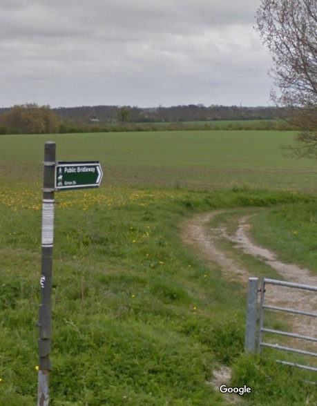
Note that there is still one footpath towards Madingley from Girton, leaving the village to the south (footpath 4, from Woody Green, then crossing the A14 on a bridge at Girton Grange), and this remains intact. I'll be referring only to the more northerly bridleway route. Of course those of us who used to enjoy a circular walk no longer have this option.
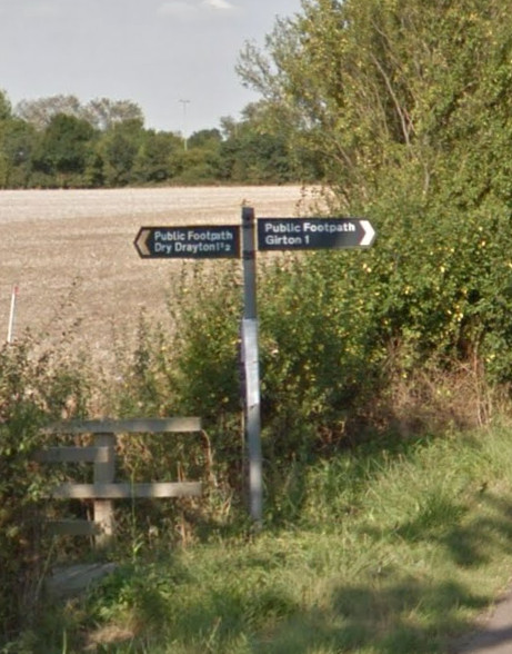
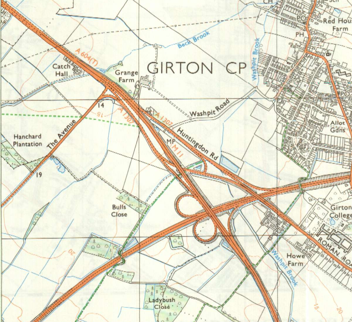
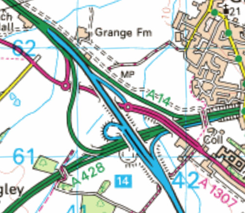
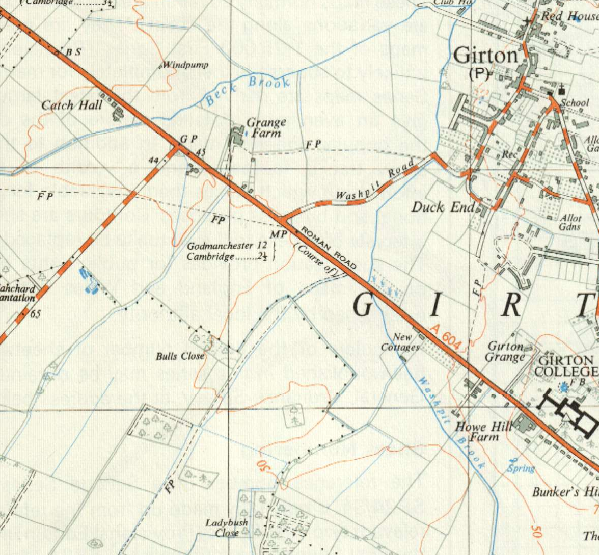
Both of the former routes entered Girton along Washpit Lane from its junction with Huntingdon Road. The historic routes are on the top-left maps; the others show more modern views. Latterly the Dry Drayton footpath was accessible only to the adventurous but the Madingley bridleway was reasonably usable. Both have become inaccessible from Girton as a result of changes made during the recent works, shown on the bottom-right map. (The OS seems not yet to have updated its 25k sheet with these changes, so the bottom-right map shows the 50k one.)
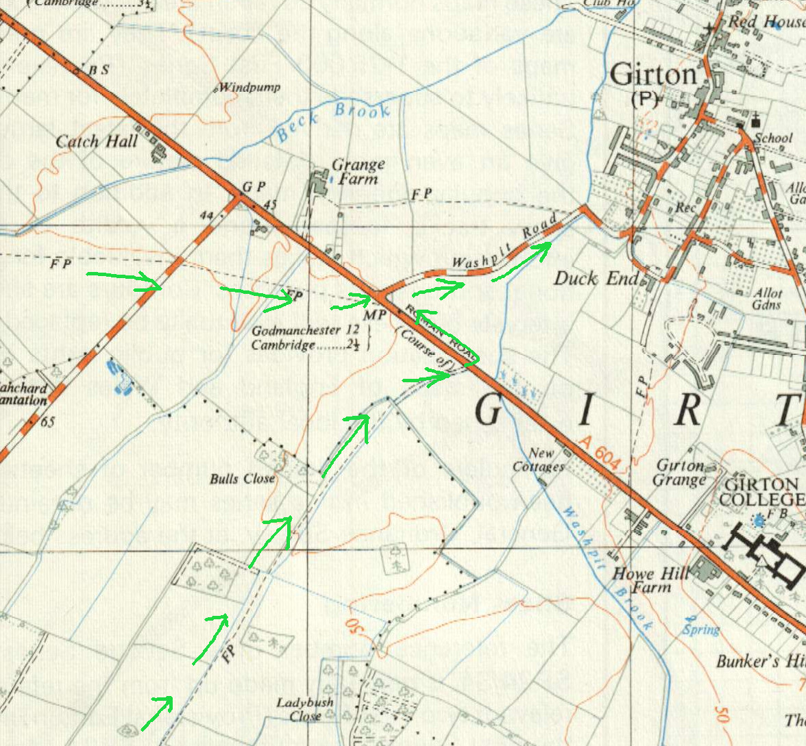
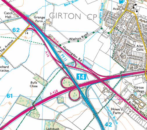
The historic routes reached Huntingdon Road directly, as shown on the 1970 OS map on the top-left above.
Following the construction of the M11 and Cambridge Northern Bypass, the Madingley bridleway (Girton bridleway 6) was preserved exactly, with an underpass under the M11 and an on-the-flat crossing of the A1307 (shown on the 1985 OS map on the top-right), which now consisted of the old Huntingdon Road carriageway plus some new sliproads. The bridleway crossed two lanes of slip road one at a time (with short paved stretches leading between), then two of main carriageway in one go. (The paved stretches tended to get rather overgrown. The Cyclestreet photomap has some photos of this.) After the carriageway there was a pavement running the short distance to Washpit Lane (and also in the other direction, towards Girton College).
The Dry Drayton footpath (Girton footpath 7) fared less well in the 1970s. As the 1985 map shows, it was cut back to make room for the M11 carriageways. It remained reachable from Washpit Lane, however, by diverting a short distance south-east to use bridleway 6 (as just described) and then walking back north-west along the verge of the “new” A1307. I say A1307 because at the time of construction, the A14 did not exist as such, and the principal anticipated traffic flow was north-south along the M11. That meant the A1307 itself was in effect the “local access road”. It was far less busy than the modern A14, and was deemed suitable for “non-motorised use”.
These phrases will be familiar if you've been reading the planners' materials during the recent works... what was once an access road is now a trunk road, so we need a new “access road”. This time, however, Girton village gets to suffer the traffic noise and pollution without even the privilege of access to the access road, nor retaining the rights of way across it. (See a separate page about what the Dry Drayton route's diversion was like to walk in recent years. It also shows some “cycle facilities” along this former road.)
In contrast to the 1970s work, the recent work has not bothered to preserve our rights of way at all. The end of Washpit Lane is already fenced off, and Girton bridleway 6, although closed “temporarily” is to be closed permanently, severing both of these routes.
The rough annotations on the right-hand map below show the 1970s changes to the Dry Drayton route.

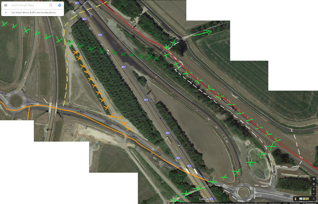
Firstly it is worth noting that the route of bridleway 6—the very short key section of these routes which crosses the A14—is basically unimpeded. Minor diversions would be required, but that does not add up to a reason for closing it. Note that the A14 is not a motorway and it is perfectly legal to walk on/across the relevant part of it. There are restrictions on parts, but there are none on this section.
I believe it would be in Girton's interests to try to keep this bridleway if we possibly can. In the short term that means simply keeping the right of way open across the A14, with the minor diversions necessary given the recent works. Plausible routes are shown in silver on this aerial photo, which shamelessly culls images from Google Maps. It also shows the historic and diverted routes in the same notations as above. The red line is the “severance line” which it is now impossible to cross, owing to the loss of access to Washpit Lane.
The most south-easterly silver line would be an obvious diversion of bridleway 6. The longer silver line would avoid the problem of crossing a drainage ditch on the Girton side, and is already paved for about half its length, so would cost roughly nothing to reinstate.
Of course using it would now be a notch more unpleasant and at least a notch less safe
than before.
In particular, the “one lane at a time” design has been lost,
because the southbound-to-eastbound sliproad has been widened to two lanes
that must be crossed in one go.
(Update, 27th December 2020: it turns out I had misremembered the layout.
It was always necessary to cross both lanes of the eastbound carriageway
in one go!
I was confusing it with the location further south-east
where one could cross the single-lane sliproad, from the sliproad pavement
onto the main carriageway pavement, walking towards Girton College.
The bridleway's crossing point in 2017 is
here on Google Street View.)
Crossing two lanes at a time is not for the faint-hearted, but plenty of trunk roads
feature such crossings. (For an example on the A11,
see this piece
which also discusses the Girton closures.)
During quieter hours,
and particularly in summer when there is plenty of daylight,
crossing here is not such an intimidating proposition.
Most importantly, preserving the right of way now will make it far more likely that a better solution may be found later, when political opportunity presents itself. One such opportunity might be if the A14 is reclassified as a motorway, as has been mooted previously (I'm not sure about the curent status of this), since this might make further funds available. The ‘gold’ dotted line on the aerial photo shows where a new route, involving a bridge, could plausibly be placed. No doubt we will have to combat hand-wringing about “budget constraints” but I believe this is the least we should expect from a £2bn project that has so far held Girton in contemptuously low regard.
Bridleway 6 really is the missing link. Beyond it, one can reach both the Madingley and the Dry Drayton routes very easily. For the former, the original continuation (Madingley bridleway 2) has now been diverted along the foot of the huge new flyover embankment. It is much less enjoyable as a result, but it does still exist. For the latter, once across the A14 one can reach the cut-back start of footpath 7 along the new shared-use footway (which on balance does beat the old verge!). Also, for cycling towards Madingley, it is rather convenient that The Avenue is now in reach without the need to brave the A1307 sliproad... or it would be, if the link to Girton had not been cut off!
Although we are past the point for planning objections, it does not mean that no other challenges are possible. Or, challenges aside, the County Council could conceivably create a fresh right of way. Some useful sources are the notification letter sent to interested parties of the Secretary of State's decision on the Development Consent Order, the order itself (see especially pages 55, 142) and a relevant part of the Planning Act 2008.
I believe that the closure process has most likely not been legally sound. There are various details that seem remiss; I am not a lawyer but I'm doing what I can to understand this better. Do contact me to find out more. (Contact from the legally trained would be especially welcome!)
Images here are copyright of their respective owners, and appear by fair use.
For interest's sake, I'd be interested if anyone could share pictures showing this area (such as Washpit Lane, footpaths etc) before the M11 and Cambridge Northern Bypass were built.
Stephen Kell
Content updated at Sun 27 Dec 13:15:00 GMT 2020.
validate this page